Every highway corridor, floodplain map, utility right-of-way, and 3D city model begins with accurate data, and much of that data is collected from the air. Aerial survey pilots fly the aircraft that carry the cameras, LiDAR units, and multispectral sensors behind modern mapping. For commercial pilots, it is one of the most practical ways to build quality flight time. For career-minded aviators, it can also become a long-term specialty in the geospatial industry.
This guide explains what aerial survey pilots do, the qualifications employers look for, typical aircraft and pay, the realities of the lifestyle, and how to position yourself for your first survey job.
What Does an Aerial Survey Pilot Do?
An aerial survey pilot flies precise, preplanned flight lines at set altitudes and airspeeds so that onboard sensors can capture consistent, overlapping data. The aircraft typically carries one or more of the following:
- Photogrammetry cameras for orthoimagery, mapping, and property assessment.
- LiDAR (Light Detection and Ranging) systems for high-accuracy elevation models, corridor mapping, and vegetation analysis.
- Multispectral and thermal sensors for agriculture, forestry, environmental, and infrastructure inspection work.
Aerial Services, Inc., for example, describes its pilots flying fixed-wing survey missions that include LiDAR, photogrammetry, and multispectral data collection (Aerial Services, Inc. Careers). The work supports engineering firms, utilities, government agencies, insurers, and environmental organizations.
Federal programs are a major driver of demand. The U.S. Geological Survey's 3D Elevation Program (3DEP) exists to meet the growing need for high-quality topographic data and is the elevation component of The National Map; USGS reports that its 3D Nation Study identified $13.5 billion in benefits across 1,352 mission-critical requirements for 3D elevation data (USGS 3D Elevation Program). Much of that data is acquired by private contractors flying manned survey aircraft.
Typical Daily Responsibilities
A real-world posting for a Cessna T206 survey pilot illustrates the scope of the role:
- Operating the aircraft safely under 14 CFR Part 91.
- Monitoring weather and making go/no-go decisions.
- Coordinating with air traffic control for access to controlled or restricted airspace.
- Hand-flying survey lines within 50 feet of the desired track.
- Working closely with a sensor operator to complete each mission.
- Arranging fuel, parking, and logistics at remote airports.
- Logging flights and reporting maintenance squawks promptly.
Precision is the core skill. A survey pilot is not simply flying from point A to point B; they are flying a grid, holding altitude, heading, and speed tightly enough to produce usable data. A poorly flown line may have to be reflown, which costs the operator fuel, time, and favorable weather.
Regulatory Framework: Why Survey Flying Is Part 91
Under federal regulations, most flights carrying persons or property for compensation require a Part 119 operating certificate. However, 14 CFR 119.1(e)(4)(iii) specifically lists aerial photography or survey as an aerial work operation to which Part 119 does not apply, except for airplanes with 20 or more passenger seats or a payload capacity of 6,000 pounds or more (eCFR, 14 CFR 119.1). As a result, most survey missions are flown under Part 91 general operating rules (eCFR, 14 CFR Part 91).
Because the pilot is being paid to fly, however, a commercial pilot certificate is still required. Under 14 CFR 61.129, the airplane commercial certificate requires at least 250 hours of flight time under Part 61, and FAA-approved Part 141 programs can reduce that minimum (eCFR, 14 CFR 61.129). Exercising commercial privileges also requires at least a second-class medical certificate (eCFR, 14 CFR 61.23).
Aerial Survey Pilot Requirements
Each operator sets its own minimums, and insurance requirements often determine them. Common requirements seen in current postings include:
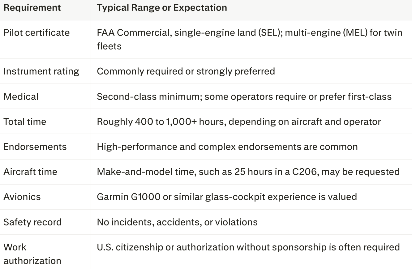
These ranges are drawn from active listings. Revolution Flight's survey pilot posting asks for a commercial certificate with an instrument rating, a first-class medical, and a minimum of 400 hours (ZipRecruiter, Aerial Survey Pilot Jobs). The T206 posting above requires 1,000+ hours, 25 hours in type, G1000 experience, and a second-class medical with first-class preferred. Aerial Services, Inc. requires a commercial SEL certificate, high-performance and complex endorsements, and a second-class medical for its survey pilot role (Aerial Services, Inc.).
For a detailed look at how flight-hour minimums compare across career paths, see the AllAviationJob.com guide, How Many Flight Hours Do You Need for Different Pilot Jobs?
Skills That Set Candidates Apart
- Precision hand-flying and disciplined instrument scan.
- Weather judgment, since survey work depends on clear skies, sun angle, and minimal cloud shadow.
- Self-sufficiency on the road, including handling fuel, lodging, and minor logistics independently.
- Crew coordination with sensor operators and data-processing teams.
- Mechanical aptitude. Some operators value or require an A&P certificate; Aerial Services, Inc. lists a combined Pilot/A&P survey role (Aerial Services, Inc.).
Adding credentials can strengthen an application. Read Five Certifications That Can Help Advance Your Aviation Career for ideas.
Common Aerial Survey Aircraft
Survey operators favor stable, reliable aircraft with good endurance, camera-port options, and the ability to fly slowly and precisely. Typical platforms include:
- Cessna 206/T206 and 210: Workhorse single-engine survey platforms.
- Cessna 208 Caravan: A turboprop single used for larger sensor payloads.
- Piper Navajo and Cessna 400-series twins: Common multi-engine survey aircraft.
- Beechcraft King Air 200 and Cessna Conquest II: Turboprop twins for higher-altitude, wide-area, and large-sensor missions.
Job listings for experienced survey captains frequently reference King Air 200, Conquest II, and Caravan experience (ZipRecruiter). Revolution Flight, for instance, advertises separate survey pilot roles for its 206 and 208 fleets (ZipRecruiter).
Aerial Survey Pilot Salary and Compensation
Aerial survey pay varies widely by aircraft, experience, and employer. Entry-level piston positions tend to pay modestly, while turbine and captain roles pay considerably more.
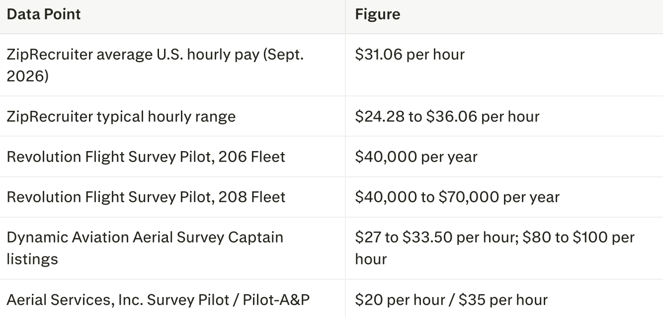
Sources: ZipRecruiter and Aerial Services, Inc.
For broader context, the U.S. Bureau of Labor Statistics reports that the median annual wage for commercial pilots was $123,220 in May 2025 (BLS Occupational Outlook Handbook). That figure covers many types of commercial flying, so entry-level survey pay will usually sit well below it, while senior turbine survey captains can approach it.
Compensation packages often include per diem, company-paid lodging during deployments, and health benefits. When comparing offers, consider total compensation, not just the hourly rate. Explore current pay trends in the AllAviationJob.com Salary Report.
The Lifestyle: Travel, Seasons, and Schedules
Aerial survey flying is not a typical nine-to-five job. Candidates should understand the trade-offs before applying.
- Extensive travel. Aerial Services, Inc. notes long-term deployments and on-call rotations, with 150+ days per year of travel for one role and 250+ days for another (Aerial Services, Inc.). The T206 posting cited above lists trips of up to 21 days.
- Weather-dependent days. Crews may wait for days for acceptable conditions, then fly long hours when the window opens.
- Seasonal peaks. Leaf-off seasons in spring and fall are prime time for LiDAR and imagery acquisition in many regions.
- High annual utilization. Some survey aircraft fly approximately 600 hours per year, which translates into meaningful logbook time for pilots.
For pilots who enjoy independence, varied destinations, and hands-on flying, these conditions can be a major advantage.
Career Path: Time-Builder or Long-Term Specialty?
Aerial survey work serves two kinds of pilots:
- Time-builders. Many low-time commercial pilots use survey work to build cross-country and PIC time toward airline or corporate minimums. AllAviationJob.com lists aerial survey among entry-level, time-building options alongside aerial photography, pipeline patrol, and ferry flying (AllAviationJob.com).
- Career survey pilots. Others stay in the geospatial industry long term, moving from piston singles into turboprop twins, chief pilot roles, sensor operations, or flight operations management.
A typical progression looks like this: commercial certificate and instrument rating, then flight instructing or other time-building, then a piston survey aircraft such as the C206, followed by multi-engine or turboprop survey aircraft and eventually captain, check airman, or chief pilot responsibilities.
How to Land an Aerial Survey Pilot Job
- Earn the right credentials. Hold a commercial certificate, instrument rating, and at least a second-class medical. Add high-performance and complex endorsements early.
- Build relevant time. Cross-country, high-performance, and glass-cockpit hours are especially valuable.
- Master precision flying. Practice holding altitude, heading, and airspeed tightly by hand.
- Tailor your resume. Highlight total time, PIC time, make-and-model experience, avionics, and a clean safety record. Free templates are available through AllAviationJob.com Resume Templates and OSI Recruit Free Resume Samples.
- Prepare for the interview. Expect questions about weather decision-making, travel flexibility, and crew coordination. Review OSI Recruit Interview Prep Tips.
- Keep your profile current. Recruiters and employers search active candidates. Learn how often you should update your aviation job profile.
- Search consistently. Watch the AllAviationJob.com Pilot Jobs category and browse aviation employers.
Military aviators transitioning to civilian work may find survey flying a natural fit. See How Military Veterans Can Launch Civilian Aviation Careers.
For Survey Operators: Hiring the Right Pilots
Aerial survey operators face a unique hiring challenge: they need pilots who can fly with precision, work independently for weeks at a time, and meet insurance minimums, often while competing with airlines for the same talent pool. OSI Recruit's aviation recruitment services help employers source and screen qualified pilots. Employers can also review The 5-Step Screening Process Every Private Aviation Employer Should Demand or contact OSI Recruit to discuss staffing needs.
Final Thoughts
Aerial survey pilot jobs offer something many entry-level flying roles do not: purposeful, precision-focused missions that produce real-world data for infrastructure, government, and environmental work. The role demands flexibility and comfort with travel, but it rewards pilots with steady flight time, hands-on experience, and a pathway into turbine aircraft or a long-term geospatial career.
Ready to Fly Your Next Mission?
Your next aerial survey pilot job could already be posted. AllAviationJob.com connects pilots with operators across the United States, from entry-level survey and time-building positions to turboprop captain roles.
- Create your free job seeker profile so employers and recruiters can find you.
- Browse the latest pilot jobs and apply today.
- Explore all aviation jobs on AllAviationJob.com.
Do not wait for the right opportunity to find you. Register on AllAviationJob.com today and take the next step in your flying career.
Sources
- Aerial Services, Inc. "Careers." https://aerialservicesinc.com/careers/
- Electronic Code of Federal Regulations. "14 CFR 119.1, Applicability." https://www.ecfr.gov/current/title-14/chapter-I/subchapter-G/part-119/subpart-A/section-119.1
- Electronic Code of Federal Regulations. "14 CFR Part 91, General Operating and Flight Rules." https://www.ecfr.gov/current/title-14/chapter-I/subchapter-F/part-91
- Electronic Code of Federal Regulations. "14 CFR 61.129, Aeronautical Experience (Commercial Pilot)." https://www.ecfr.gov/current/title-14/chapter-I/subchapter-D/part-61/subpart-F/section-61.129
- Electronic Code of Federal Regulations. "14 CFR 61.23, Medical Certificates: Requirement and Duration." https://www.ecfr.gov/current/title-14/chapter-I/subchapter-D/part-61/subpart-A/section-61.23
- U.S. Bureau of Labor Statistics. "Airline and Commercial Pilots," Occupational Outlook Handbook. https://www.bls.gov/ooh/Transportation-and-Material-Moving/Airline-and-commercial-pilots.htm
- U.S. Geological Survey. "3D Elevation Program." https://www.usgs.gov/3d-elevation-program
- ZipRecruiter. "Aerial Survey Pilot Jobs" (pay data as of September 2026). https://www.ziprecruiter.com/Jobs/Aerial-Survey-Pilot
- AllAviationJob.com. "How Many Flight Hours Do You Need for Different Pilot Jobs?" https://www.allaviationjob.com/blog/how-many-flight-hours-do-you-need-for-different-pilot-jobs-